 DEMO Paikkatietohakemisto
Administrative units
Type of resources
Available actions
Topics
Keywords
Contact for the resource
Provided by
Years
Formats
Representation types
Update frequencies
Service types
Scale
-
WFS download service for ELF Administrative Units dataset of Finland
-
NLS-FI INSPIRE Download Service (WFS) for Administrative Units Theme is an INSPIRE compliant direct access Web Feature Service. It contains the following INSPIRE feature types: AdministrativeUnit, AdministrativeBoundary, Baseline, MaritimeZone, MaritimeBoundary. The service is based on the NLS-FI INSPIRE Administrative Units dataset. The dataset is administrated by the National Land Survey of Finland.
-
NLS-FI INSPIRE Administrative Units Theme Dataset is a dataset depicting Administrative Units covering the land area and Maritime Units covering the sea area of Finland. Administrative Units contain the following INSPIRE feature types: AdministrativeUnit, AdministrativeBoundary. Maritime Units contain the following INSPIRE feature types: Baseline, MaritimeZone, MaritimeBoundary. Administrative Units are updated once a year from the NLS Cadastral Index Map database. Maritime Units are quite stable and have no regular update cycle. The dataset is available via the NLS-FI INSPIRE Download Service (WFS) for Administrative Units Theme and it can be viewed via the NLS-FI INSPIRE View Service (WMS) for Administrative Units.
-

Municipal Division is a dataset depicting the municipal division in the whole of Finland. The Municipal Division dataset is produced in scales 1:10,000, 1:100,000, 1:250,000, 1:1,000,000 and 1:4,500,000. The data included in the dataset in scale 1:10,000 are taken from the cadastral registry. Regarding other scales, municipal boundaries have been generalised to suit the scale in question. The Municipal Division dataset is available as products both in vector and raster format. The products in vector format contain the number codes of the municipalities, the names of the municipalities in both Finnish and in Swedish as well as municipal boundaries and municipal geographical areas. In addition, the vector product includes the corresponding information about the regions, the State Administrative Agencies and the nation as well as a specification of the municipality's area into land and water area in MapInfo and Shape format. Products in raster format include municipal boundaries only. The product belongs to the open data of the National Land Survey of Finland. More information: Topographic data and how to acquire it http://www.maanmittauslaitos.fi/en/maps-and-spatial-data/expert-users/topographic-data-and-how-acquire-it .
-
NLS-FI INSPIRE View Service for Administrative Units Theme is an INSPIRE compliant Web Map Service. It contains the following harmonized INSPIRE map layers: AdministrativeUnit, AdministrativeBoundary, Baseline, TerritorialSea, ExclusiveEconomicZone, MaritimeBoundary.InternalWaters, MaritimeBoundary.TerritorialSea ,MaritimeBoundary.ExclusiveEconomicZone. The service is based on the NLS-FI INSPIRE Administrative Units dataset. The dataset is administrated by the National Land Survey of Finland.
-
Palvelun kautta saa käyttöön ajantasaiset rasterimuotoiset perus-, maasto- ja yleiskartat sekä ilmakuvat. Palvelu on tarkoitettu WMTS-standardia tukevien sovellusten käyttöön. Lisätietoja http://www.maanmittauslaitos.fi/aineistot-palvelut/rajapintapalvelut/karttakuvapalvelu-wmts Palvelun käyttö on maksullista ja vaatii käyttäjätunnuksen ja salasanan.
-
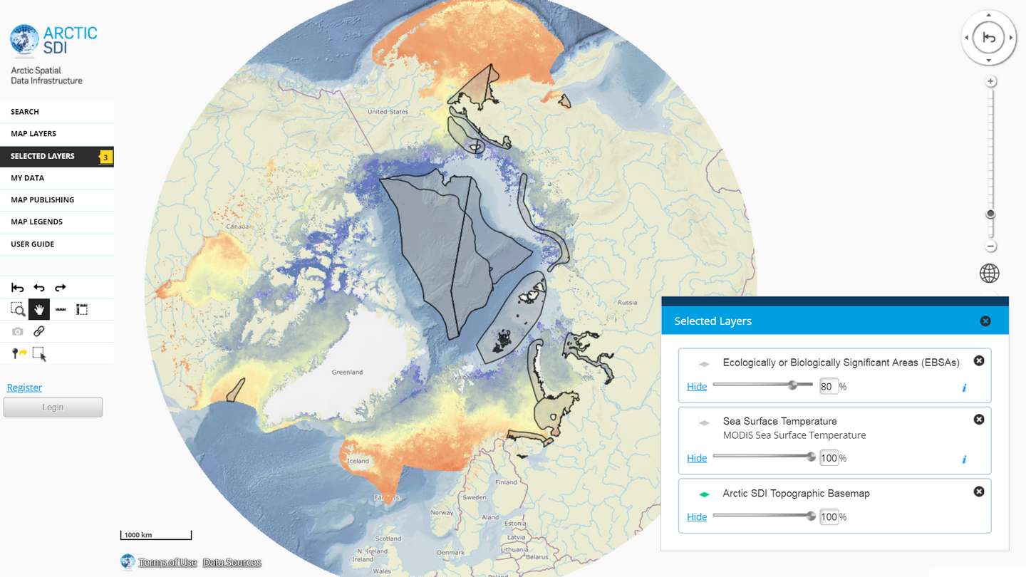
The Arctic SDI Geoportal provides access to geospatial data and services available via the Arctic SDI to support and facilitate monitoring, management and decision making, and support sustainable development in the Arctic. Specifically, the Arctic SDI Geoportal facilitates the discovery, visualization, evaluation, download and integration of geographic data from a variety of sources for the Arctic. The Arctic SDI Geoportal is the result of cooperative efforts between the National Mapping Agencies (NMAs) of the eight Arctic Council Member countries - Canada, Denmark, Finland, Iceland, Norway, Russia, Sweden and the United States. The Arctic SDI Geoportal includes reference data (such as the Arctic SDI topographic basemap or Pan-Arctic Digital Elevation Model) and thematic data from various sources. Thematic data section includes themes such as oceans, climatology and geoscientific information. Most of the data covers the Arctic or the involved Arctic countries, but new data sources with a smaller or larger geographical extent may be accepted. The Geoportal allows searching placenames via a circumpolar gazetteer, and embedding interactive maps to any website. Some of the features require registration.
-

The Topographic database is a dataset depicting the terrain of all of Finland. The key objects in the Topographic database are the road network, buildings and constructions, administrative borders, geographic names, land use, waterways and elevation. Aerial photographs, scanning data and data provided by other data providers are utilised in updating the Topographic database. The updating is done in close cooperation with the municipalities. Field checks in the terrain are also needed to some extent, mostly as regards the classification of features. The topographic database is used in the production of other map products and in various optimisation tasks. The product belongs to the open data of the National Land Survey of Finland. More information: Topographic data and how to acquire it http://www.maanmittauslaitos.fi/en/maps-and-spatial-data/expert-users/topographic-data-and-how-acquire-it.
-

Paikkatietohakemisto is a national metadata discovery service.